Beneath the Surface
Charting the Mahomet Aquifer for Water Security
The precise physical area of the Mahomet aquifer in central Illinois has long been shrouded in mystery, its range estimated based on scant data from a disparate collection of private well drilling and geological core samples. However, a groundbreaking technology known as helicopter-based time-domain electromagnetics (HTEM) is poised to revolutionize our understanding of this vital water source, laying the groundwork for critical and equitable water management and governance.
SkyTEM helicopter-based time-domain electromagnetics (HTEM) at Frasca Airfield. Image by Fred Zwicky, University of Illinois Urbana-Champaign.
Cutting-edge investigations will result in the most accurate maps of the aquifer to date
Currently underway in Ford, Iroquois, and Vermilion County, and with data from 2023 available soon for Champaign County, HTEM represents a new frontier in aquifer characterization and geologic capabilities. HTEM promises increased precision and accuracy over traditional methods. Thanks to support from the United States Geological Survey and other partners, the SkyTEM team, the company conducting the aerial surveys, is mapping the eastern portion of the aquifer. A single helicopter flying along transects across the counties and transmitting electromagnetic pulses penetrating up to 600 feet below the Earth’s surface, can create detailed 3D images or maps of the subterranean layers.
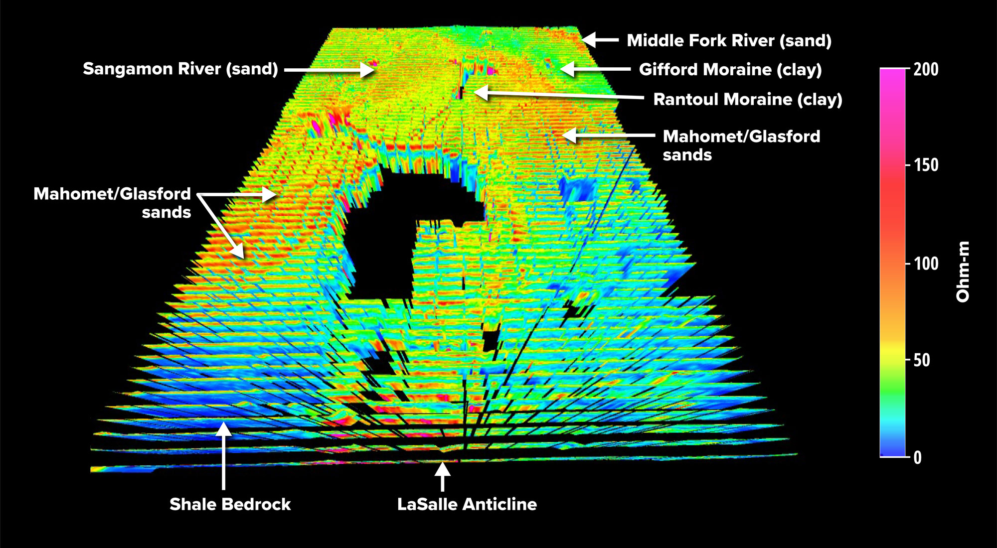
An overview of HTEM collected in Champaign County, courtesy of Kisa Mwakanyamale-Gilkie.
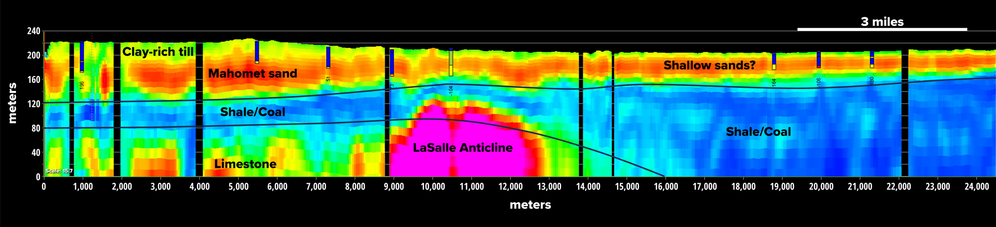
A two-dimensional example from a transect taken HTEM over Champaign County detailing the subterranean layers, courtesy of Kisa Mwakanyamale-Gilkie.
The maps delineate the sedimentary layers and ascertain the conditions that give rise to the aquifer. The resulting data will provide a comprehensive depiction of the aquifer’s boundaries, offering invaluable insights into its composition and potential water reserves.
As the findings of these endeavors come to light, stakeholders stand on the brink of a new era in water resource management and governance.
“How the ground beneath our feet is organized to hold the water we rely on is still somewhat mysterious,” said Kisa Mwakanyamale-Gilkie, geophysicist and project lead at the Illinois State Geological Survey (ISGS), a division of the Prairie Research Institute. “Hydrologically, the data we are collecting will have crucial information with implications for irrigation, domestic water use, and economic growth for this area.”
SkyTEM helicopter-based time-domain electromagnetics (HTEM) at Frasca Airfield. Image by Fred Zwicky, University of Illinois Urbana-Champaign.
Water security and the need for equitable water governance
With water scarcity looming as a global challenge, the Mahomet aquifer’s groundwater reserves, consumption, and recharge, assume newfound significance. Its waters not only sustain drinking water for nearly 500,000 residents but also drive agricultural activities vital to the region’s economy.
“These [HTEM] data will be imported into our groundwater flow model, which is continually being updated, helping us to better understand recharge to the aquifer and better forecast water availability for communities and individuals who rely on the Mahomet aquifer system for their water,” said Dan Hadley, hydrogeologist at the Illinois State Water Survey (ISWS) at PRI.
In Joliet, Illinois, for example, previous groundwater flow models provided crucial data projecting increasing demand and depletion of groundwater reserves by 2030.
In central Illinois, it is difficult to estimate water demand. “While non-irrigation demand like domestic consumption or industry has not increased as much as previously forecasted,” says Daniel Abrams, groundwater flow modeler at ISWS. “Center pivot irrigation has increased faster than projected, especially after the 2012 drought, which was not foreseen in the original study.”
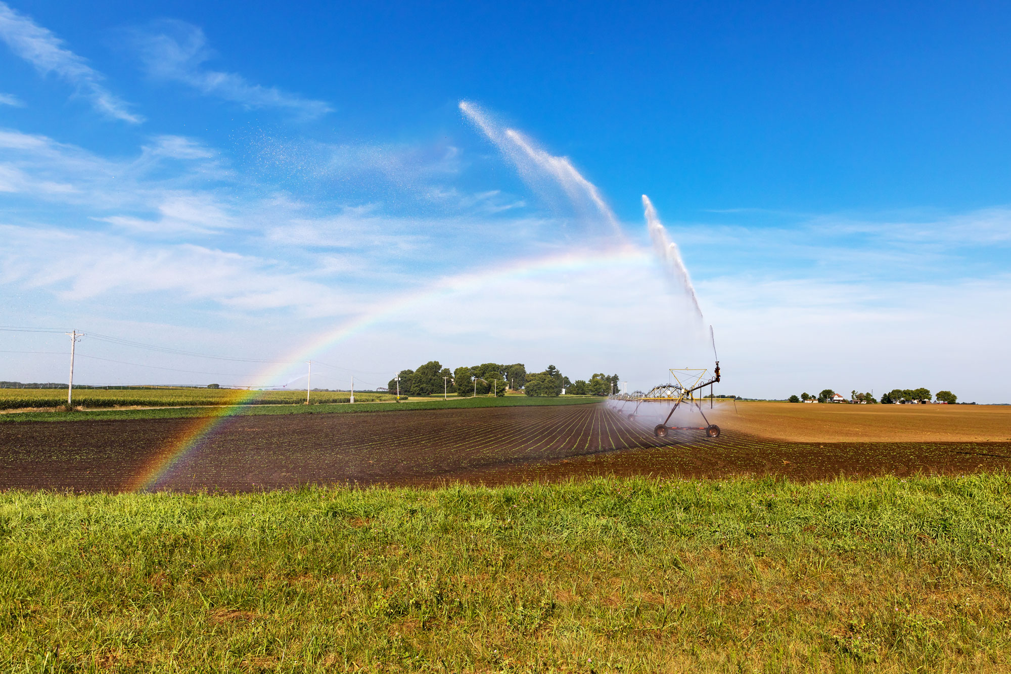
Center pivot irrigation.
Moreover, the specter of climate change casts a shadow over water security. As witnessed in the recent plight of the Colorado River in 2023, a fluctuating climate is threatening to disrupt the water cycle, which, in the case of the Mahomet aquifer, could impact its recharge mechanisms, jeopardizing the quantity of water available in the aquifer.
Water quality must also be considered. Groundwater contamination may originate from below ground through natural processes as well as from aboveground from anthropogenic origins like pollution. When asked, Hadley stated that arsenic, a naturally occurring contaminant, is the most important water quality concern in eastern Illinois. “Arsenic is prevalent in shallower sand and gravels in the Mahomet aquifer system,” he said. “Unfortunately, it is very difficult to predict exactly where the elevated arsenic concentrations occur.” Hadley continued, “The aquifer is generally well protected from surface contaminants such as nitrate due to the thick layer of low permeability sediments overlying it in the eastern region.”
Put simply, equitable access to water is assured when water quantity and quality are known. HTEM data, coupled with additional groundwater flow models and research, will begin to provide the most accurate estimate of water reserves in the region. By leveraging the insights gleaned from HTEM, policymakers can chart a course toward sustainable water management and equitable governance. Whether through conservation efforts, diversification of water sources, or strategic infrastructure investments, proactive measures are essential to safeguarding our water resources, especially in at-risk communities.
The significance of water as a universal right cannot be overstated.
When asked about when these results will be publicly accessible, Mwakanyamale-Gilkie said, “Preliminary results may be available to the public within 6-12 months after data collection. But it will likely take a minimum of two years for the data to be used in policymaking.”
As the data from Champaign County undergoes analysis and mapping efforts could expand to nearby counties, particularly westward, the stage is set for a comprehensive reevaluation of the Mahomet aquifer. Armed with new knowledge, policymakers will be able to navigate the complexities of water governance with clarity, ensuring equitable access for generations to come.
For more information about the HTEM project, updates, and additional information, please visit Mahomet Aquifer Mapping.
Wednesday, March 6, 2024